Postcode E2A - Bathurst, New Brunswick
New Brunswick | Canada
| Grootste stad | Bathurst |
| Gebied van Postcode E2A | 1,951.6 km² |
| Bevolking | 17,937 |
| Mannelijke bevolking | 8,704 (48.5%) |
| Vrouwelijke bevolking | 9,233 (51.5%) |
| Bevolkingsverandering van 1975 tot 2015 | -8.6% |
| Bevolkingsverandering van 2000 tot 2015 | -5.6% |
| Gemiddelde leeftijd | 48.3 jaren |
| Gemiddelde leeftijd bij de mannen | 47.4 jaren |
| Gemiddelde leeftijd bij de vrouwen | 49.1 jaren |
| Netnummers | 506 |
| Postcode-uitbreidingen | E2A 0A1, E2A 0A2, E2A 0A3, E2A 0A4, E2A 0A5, E2A 0A6, E2A 0A7, E2A 0A8, E2A 0A9, E2A 0B1 More |
| Vergelijkbare steden | Tracadie-Sheila |
| Buurten | Rough Waters |
| Timezone | Bolivia Time |
| coördinaten | 47.619209162163735° / -65.66417487934896° |
| Gerelateerde Postcodes | E2E, E2G, E2H, E2J, E2K, E2L, E2M, E2N, E2P, E2R |
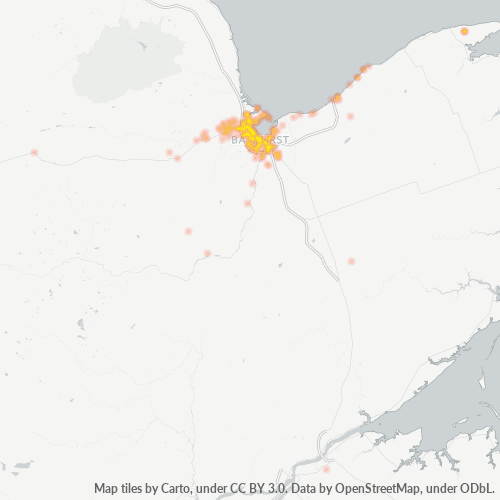
Kaart van Postcode E2A - Bathurst, New Brunswick
Interactieve kaart
Bevolking van Postcode E2A - Bathurst, New Brunswick
Jaren 1975 tot 2020
| Data | 1975 | 1990 | 2000 | 2015 | 2020 |
|---|---|---|---|---|---|
| Bevolking | 19.618 | 19.538 | 18.997 | 17.937 | 18.863 |
| Bevolkingsdichtheid | 10,1 / km² | 10 / km² | 9,7 / km² | 9,2 / km² | 9,7 / km² |
Bronnen: JRC (European Commission's Joint Research Centre) werken aan de GHS-bebouwingsraster
Bevolkingsverandering van Postcode E2A - Bathurst, New Brunswick van 2000 tot 2015
Daling van 5.6% van jaar 2000 tot 2015
| Locatie | Verandering sinds 1975 | Verandering sinds 1990 | Verandering sinds 2000 |
|---|---|---|---|
| Postcode E2A - Bathurst, New Brunswick | -8.6% | -8.2% | -5.6% |
| Bathurst | -8.6% | -8.2% | -5.6% |
| New Brunswick | +24.1% | +12.8% | +7.4% |
| Canada | +55.8% | +30.2% | +17.2% |
Bronnen: JRC (European Commission's Joint Research Centre) werken aan de GHS-bebouwingsraster
Mediane leeftijd in Postcode E2A - Bathurst, New Brunswick
Mediane leeftijd: 48.3 jaar
| Locatie | Gemiddelde leeftijd | Mediane leeftijd (vrouw) | Mediane leeftijd (mannelijk) |
|---|---|---|---|
| Postcode E2A - Bathurst, New Brunswick | 48.3 yrs | 49.1 yrs | 47.4 yrs |
| Bathurst | 48.8 yrs | 50 yrs | 47.4 yrs |
| New Brunswick | 44 yrs | 44.9 yrs | 43 yrs |
| Canada | 40.6 yrs | 41.5 yrs | 39.6 yrs |
Bronnen: CIESIN (Center for International Earth Science Information Network)
Bevolkingsdichtheid van Postcode E2A
Bevolkingsdichtheid: 9,2 / km²
| Locatie | Bevolking | Gebied | Dichtheid |
|---|---|---|---|
| Postcode E2A | 17.937 | 1.951,6 km² | 9,2 / km² |
| Bathurst | 12.496 | 116,8 km² | 107 / km² |
| New Brunswick | 783.302 | 76.912,8 km² | 10,2 / km² |
| Canada | 35,5 million | 9.875.295,4 km² | 3,6 / km² |
Bronnen: JRC (European Commission's Joint Research Centre) werken aan de GHS-bebouwingsraster
Historische en geprojecteerde bevolking van Postcode E2A - Bathurst, New Brunswick
Geschatte bevolking van 1710 tot 2100
Bronnen:
- JRC (European Commission's Joint Research Centre) werken aan de GHS built-up grid
- CIESIN (Center for International Earth Science Information Network)
- [Link] Klein Goldewijk, K., Beusen, A., Doelman, J., and Stehfest, E.: Anthropogenic land use estimates for the Holocene – HYDE 3.2, Earth Syst. Sci. Data, 9, 927–953, https://doi.org/10.5194/essd-9-927-2017, 2017.
Bedrijfsconcentratie in Postcode E2A - Bathurst, New Brunswick
Bedrijfsspreiding voor Postcode E2A - Bathurst, New Brunswick
Human Development Index (HDI)
Statistische samengestelde index van levensverwachting, opleiding en inkomen per hoofd van de bevolking.
Bron: [Link] Kummu, M., Taka, M. &Guillaume, J. Gridded global datasets for Gross Domestic Product and Human Development Index over 1990–2015. Sci Data 5, 180004 (2018) doi:10.1038/sdata.2018.4
CO2-uitstoot van Postcode E2A
Kooldioxide (CO2) -emissies per hoofd van de bevolking in ton per jaar
| Locatie | CO2 uitstoot | CO2-uitstoot per hoofd van de bevolking | CO2-emissie-intensiteit |
|---|---|---|---|
| Postcode E2A | 240,575 tn | 13.41 tn | 123.3 tons/km² |
| Bathurst | 119,983 tn | 9.6 tn | 1,027.6 tons/km² |
| New Brunswick | 10,355,804 tn | 13.22 tn | 134.6 tons/km² |
| Canada | 521,999,336 tn | 14.7 tn | 52.9 tons/km² |
Bronnen: [Link] Moran, D., Kanemoto K; Jiborn, M., Wood, R., Többen, J., and Seto, K.C. (2018) Carbon footprints of 13,000 cities. Environmental Research Letters DOI: 10.1088/1748-9326/aac72a
CO2-uitstoot van Postcode E2A
| CO2-uitstoot 2013 (ton/jaar) | 240,575 tn |
| CO2-uitstoot 2013 (ton/jaar) per hoofd van de bevolking | 13.41 tn |
| CO2-uitstootintensiteit 2013 (ton/km²/jaar) | 123.3 tons/km² |
Natuurlijk gevarenrisico
Relatief risico op 10
| Gevaar | Risiconiveau |
|---|---|
| Aardbeving | Gemiddeld (4) |
* Risico, met name met betrekking tot overstromingen of aardverschuivingen, is mogelijk niet voor het hele gebied.
Recente aardbevingen in de buurt
Magnitude 3.0 en hoger
| Datum▼ | Tijd↕ | Magnitude↕ | Distance↕ | Diepte↕ | Locatie↕ | Link |
|---|---|---|---|---|---|---|
| 11/1/16 | 1:49 PM | 3.1 | 55.7 km | 5,000 m | 23km WNW of Miramichi, Canada | usgs.gov |
| 11/4/15 | 7:04 AM | 3.7 | 98.5 km | 5,000 m | 88km W of Miramichi, Canada | usgs.gov |
| 4/28/14 | 7:52 AM | 3.4 | 97.1 km | 5,000 m | 84km W of Miramichi, Canada | usgs.gov |
| 8/28/13 | 2:44 AM | 3.2 | 99.7 km | 5,000 m | 86km W of Miramichi, Canada | usgs.gov |
| 3/30/12 | 4:29 PM | 3.4 | 43.8 km | 5,000 m | New Brunswick, Canada | usgs.gov |
| 7/19/07 | 5:35 PM | 3.2 | 63.1 km | 5,000 m | New Brunswick, Canada | usgs.gov |
| 1/5/05 | 7:32 AM | 3.7 | 96.3 km | 5,000 m | New Brunswick, Canada | usgs.gov |
| 7/15/98 | 12:08 AM | 4 | 97.7 km | 5,000 m | New Brunswick, Canada | usgs.gov |
| 5/6/95 | 12:51 AM | 3.9 | 98.7 km | 5,000 m | New Brunswick, Canada | usgs.gov |
| 7/14/94 | 5:41 AM | 3.8 | 98.7 km | 5,000 m | New Brunswick, Canada | usgs.gov |
1-10 of 34 tonen...
…
Postcode-uitbreidingen (1.141)
Over onze gegevens
De gegevens op deze pagina zijn geschat met behulp van diverse openbaar beschikbare tools en bronnen. Ze worden aangeboden zonder garantie en kunnen onnauwkeurigheden bevatten. Gebruik op eigen risico.